A plot of known Anglo-Saxon settlements on the map of England
shows a frontier line running north-south along the Trent washlands of
south-west Nottinghamshire and Derbyshire. There are many settlements to the
east of this line and very few to the west, Catholme is exceptional. Yet coins
and graves have been found west of the line. This suggests in the 6th and early
7th century Lichfield would have been on a marginal border and the inhabitants
pioneer colonists.
 |
| Majority of early Saxon settlements are east of the line. By the late Saxon period, settlements are on a line close to the River Severn. By 850–1050, settlements and coins have been found close to the current Welsh border. |
Several reasons for this invisibility of settlements in the
West Midlands have been given. Perhaps, by the beginning of the 7th century
people had not migrated across middle England and settled. Perhaps, their
dwellings were unlike the timber buildings of the east (post, post in trench
and sunken featured buildings) and they left no trace in any excavation; instead,
they were erecting turf, cobble or loose stone and rubble buildings. Did they
prefer to move around in temporary buildings (including tents) which could be
dismantled and moved on? Have soil stains, ground depressions, floors and even
stake holes not survived so well in the wetter, western climate? It has been argued
settlement patterns were largely a consequence of environmental factors, such
as the influence of climate, soils and hydrology, and of the patterns of
contact and communication engendered by natural topography.[1] The
drier east was more conducive to survival. It is therefore no surprise for a paucity
of excavated early Anglo-Saxon settlements in the West Midlands and
particularly around Lichfield.
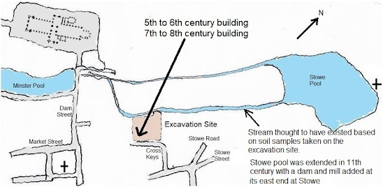
Before a two-storey car park was
built on Cross Keys Road, an excavation was conducted at the end of 2005 and
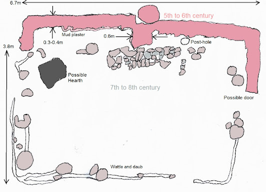
into 2006. Two remarkable buildings were found. The north end of a
two-chambered building was uncovered around a rectangular pit around 0.4 m
deep. Walls contained Roman masonry with yellow mortar attached and bonded
together with boulder clay. A twig in the mortar was carbon dated to 89–334.
The floor contained rye and wheat grains and there were traces of barley, small
mammals and fish bones. A twig in this detritus was carbon dated to 436–636.
Charcoal was also found dated to 604–683. Mud plaster on the walls, 10 mm
thick, suggested it was possibly a dwelling. The grains suggested it might have
become a store and the charcoal hints it was destroyed by fire.
 |
| Cross Keys excavation site |
On its south side was a 7th to 8th century timber building
around a new pit and cut deeper into the ground. Post-holes suggested a
dwelling similar to those found at Catholme, but larger. Supporting posts were
in the corners and along the middle line of the building. Wattle and daub
looked to have been used for infill. A twig found near the wattle was dated to
688–868.
 |
| The upper building is 5th to 6th century, or even later, but has stones with Roman plaster. The lower building is 7th to 8th century. |
Sargent[2] using notes from the archaeologist,[3]
described the early building as unique in Britain. Being stone built and mud
plastered suggested a monastic cell, however, the position of the putative
doorway, little wear of the floor and its sunken pit does not entirely fit.
Sargent compared it with the sunken crypt at Repton and even the possibility it
was a funerary mausoleum. It might have pre-dated the early church. Sargent
reappraises the many conjectures on how the polyfocal area of Lichfield grew
from early times. He noted[4]
that early to mid-Anglo-Saxon pottery
sherds, 5th to 9th centuries, were found during excavation of a site to the
north of Sandford Street supporting an
early medieval occupation around the northern end of Bird Street.[5]
NB. There
is a problem with naming the people Saxon or Anglo-Saxon (the preferred title
in academic publications). Based on surviving texts, early inhabitants of the
region were commonly called englisc and angelcynn. From
410 A.D. when the Romans left to shortly after 1066, the term only
appears three times in legal charters in the entire corpus of Old English
literature and all in the tenth century. It is used here because Anglo-Saxon is
understood.
[1]
T. Williamson, Environment, Society and Landscape in early medieval England:
Time and Topography. (Woodbridge: 2015).
[2]
A. Sargent, ‘Early medieval Lichfield. A reassessment’. Staffordshire
Archaeological and Historical Society Transactions, (2013), 1–32.
[3]
N. Tavener, Cross Keys Car Park, Lichfield, Staffordshire. Level 3 archive
report on an archaeological excavation and watching brief. (unpub. report, Nick
Tavener Archaeological Services) (2010).
[4]
See Sargent (2013), 5.
[5]
K. Nichol and S. K. Rátkai, Archaeological
Excavations on the North Side of Sandford Street, Lichfield, Staffordshire,
2000 (unpub.report, Birmingham University Field Archaeology Unit) (2002), 14.


